Support OpenDurham.org
Preserve Durham's History with a Donation to Open Durham Today!
OpenDurham.org is dedicated to preserving and sharing the rich history of our community. Run by our parent nonprofit, Preservation Durham, the site requires routine maintenance and upgrades. We do not ask for support often (and you can check the box to "hide this message" in the future), but today, we're asking you to chip in with a donation toward annual maintenance of the site. Your support allows us to maintain this valuable resource, expand our archives, and keep the history of Durham accessible to everyone.
Every contribution, big or small, makes a difference and makes you a member of Preservation Durham. Help us keep Durham's history alive for future generations.
Comments
Submitted by wren (not verified) on Thu, 1/22/2009 - 7:57am
I'm excited that you're covering this part of town. I grew up in Bragtown, and there are several old (now gone) buildings about which I've always been curious.
This spot brings back memories. In the 60s, that McDonad's (on the left) was one of the old-style red and white striped with the huge arches that arched over the entire building. Relatives lived within walking distance, and it seemed like you could smell French fries from their house. (No doubt the imagination of a pre-schooler can conjure such things.)
I have to laugh; now McD's is practically an everyday thing, but it was a rare treat for us to walk over for a small drink and fries. I was a sad kid when they remodeled that and the old drive-up Shoney's. It took some of the fun out of going.
Submitted by Anonymous (not verified) on Thu, 1/22/2009 - 12:02pm
I remember the old Shoneys and Pizza Hut as well! I was pretty sad when Pizza Village threw in the towel a few years back but that whole area has been sliding downhill for a while, especially being anchored by K-Mart Plaza or whatever it's being called nowadays
Submitted by Sue (not verified) on Thu, 1/22/2009 - 8:50pm
Not immediately relevant, but I am trying to figure out what the huge boarded up brick building on Main at Watts used to be. New to the area and think Endangered Durham is incredible. I'm a junkie for this stuff. Sue
Submitted by Gary (not verified) on Thu, 1/22/2009 - 8:56pm
Sue
Thank you! It's the old McPherson Hospital - Check this post. You can always use the map linked to the left to help identify places that you don't know the name of, but can find them on the map.
GK
Submitted by wren (not verified) on Fri, 1/23/2009 - 10:01pm
Pizza Village. Wow. I've not thought about that in many years.
Is the Kmart building at the end of Foushee still empty?
Submitted by Anonymous (not verified) on Sun, 1/25/2009 - 10:16pm
^yep Kmart is still empty along with the old Carmike movie theater leaving Big Lots and that grocery store that replaced Winn Dixie, Compare Foods as anchors...I would love to see a pic of Pharmor when it was in that center...
Submitted by Anonymous (not verified) on Tue, 6/1/2010 - 7:39pm
Revealing my age to you youngsters, before McDonalds golden arches moved there, it was Neal's Drive In. On the other side of the street was the OhBoy, home of the Hi-Boy hamburger, McD's never had a burger that good. Most of my friends didn't care too much for McD's then, except for the fries. Sometime after the OhBoy I think there was a hot dog place there that advertised "steamed in beer" dogs. I wasn't around much then, but I still miss the OhBoy.
This site is fanatastic, by the way, I remember a lot of the places that are now gone, wishing I had paid more attention, but bringing back fond memories.
Submitted by Elizabeth "Buf… (not verified) on Sat, 2/19/2011 - 7:30pm
The "steamed" hot dog place was "Lums". Steamed hot dogs were not what we wanted when you could go have an Amos and Andy dog, downtown. Lums sat were the Subway is now...and before that was Pizza Village. Next to where the Pic 'n Pay shoes. The McD's moved a couple of times too. As I remember it...it was orginially where it is now...but it moved to where the parking and the current Arby's is now...which used to be Bunkey's Carwash was in the 70's. The Chesterfield Motel was next to Shoney's. You could get 2 burgers, fries and a drink for under a dollar at McD...and they were still counting burgers in the thousands at that time...remember that on the signs...and they would change the numbers. Burgers were 20 cents and cheese burgers were 25. I miss the old Arby's building that looked like a hat...and that was not that long ago. My 20 yr. old son remembers that. I grow up in Duke Park (61) and bought my first hoome there too (88).
Submitted by Jeff Sell (not verified) on Tue, 4/29/2014 - 12:51pm
Anybody remember the funky motel that was across (south) from Arby's? now it's a field...
Submitted by Ace (not verified) on Mon, 8/25/2014 - 12:09pm
The Chesterfield, had to stay there once.
Submitted by Durhamite (not verified) on Mon, 8/25/2014 - 11:28pm
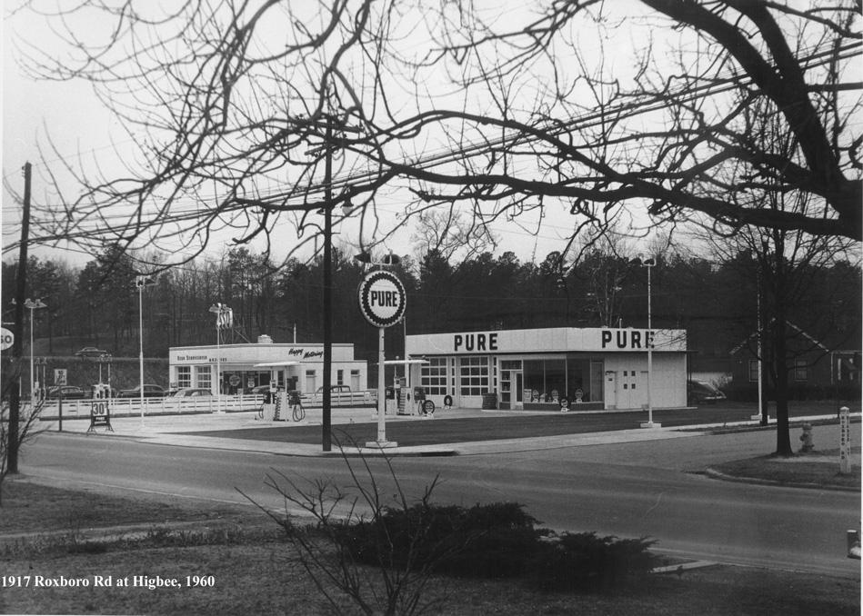
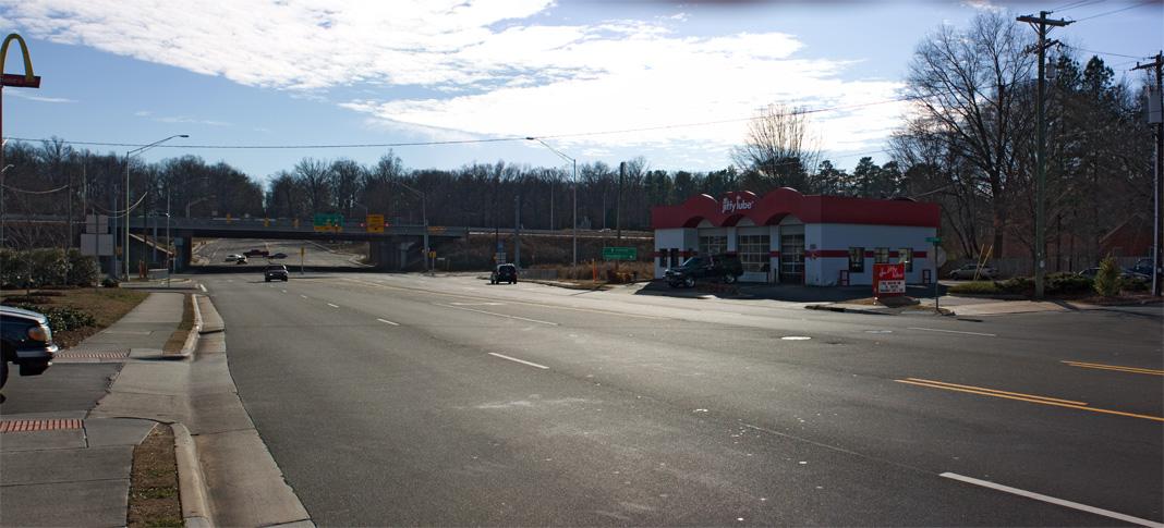
Did anyone notice how clean and crisp both the Esso and Pure stations appeared in the 1960 photo? Not such a traveler's oasis in the contemporary view.
Add new comment
Log in or register to post comments.