Preserve Durham's History with a Donation to Open Durham Today!
OpenDurham.org is dedicated to preserving and sharing the rich history of our community. Run by our parent nonprofit, Preservation Durham, the site requires routine maintenance and upgrades. We do not ask for support often (and you can check the box to "hide this message" in the future), but today, we're asking you to chip in with a donation toward annual maintenance of the site. Your support allows us to maintain this valuable resource, expand our archives, and keep the history of Durham accessible to everyone.
Every contribution, big or small, makes a difference and makes you a member of Preservation Durham. Help us keep Durham's history alive for future generations.
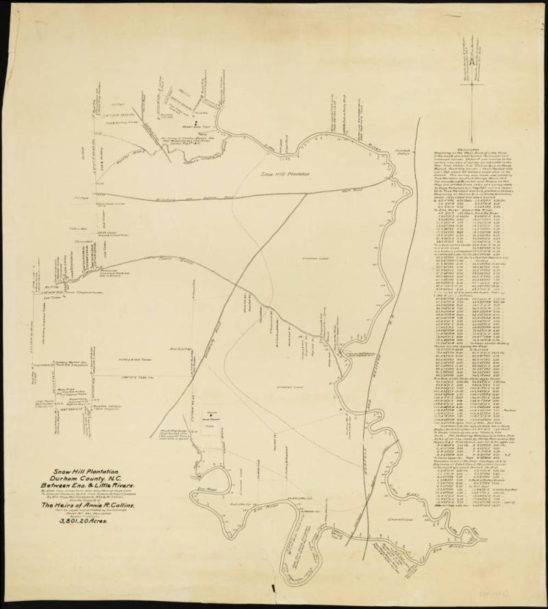
1917 survey of the Cameron-Collins lands at the south of Snow Hill Plantation
Sometime during the era of Cameron and Collins ownership of lands along the Eno River [1700s - 1942], a natural, loopy bend of the Eno River– located at the southern limit of the Cameron-Collins Snow Hill Plantation lands– was transformed by human impact. A canal appears to have been dug at the area where the two parts of the loop (see the bend in the channel just west of Penny's Bend) veer nearest to one another, essentially re-channeling the river to create a more direct route for water to flow downstream.
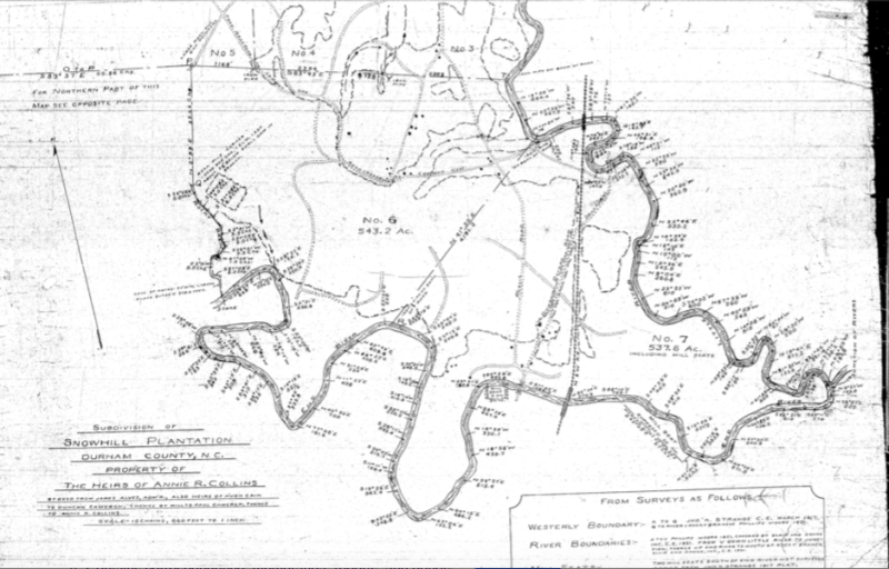
1921 survey of the Cameron-Collins lands at the south of Snow Hill Plantation
Early maps– like these surveys undertaken in 1917 and 1921 when Snow Hill Plantation was broken up and distributed among the Collins heirs (the children of Annie Cameron Collins)– show no such change to the landscape.
Some historians theorize that a channel like this would have been dug by enslaved laborers, perhaps during the time when Archibald Murphey, a personal friend of the Camerons, proposed that the solution to North Carolina's 19th century navigation problems could by solved by building canals in the rivers. This seems unlikely, given how shallow the river is around this bend and the neighboring Penny's Bend (floating anything up and down river here would be heavily dependent on rainfall). The Camerons often had trouble with flooding at their mill on the east side of Penny's Bend (near where Old Oxford Rd crosses the river), so the idea of speeding up the flow of water just to the west seems unlikely as a venture that the Camerons would have required their forced laborers to complete, particularly on this marginal part of their plantation (Snow Hill, Stagville, and Fairntosh are far to the northeast). What's more, to my knowledge, none of the early maps of the plantation document such a channel, which, if it were undertaken at Murphey's behest, seems likely to have been documented and shared as an example of his theory at work (no such documentation exists, to my knowledge).
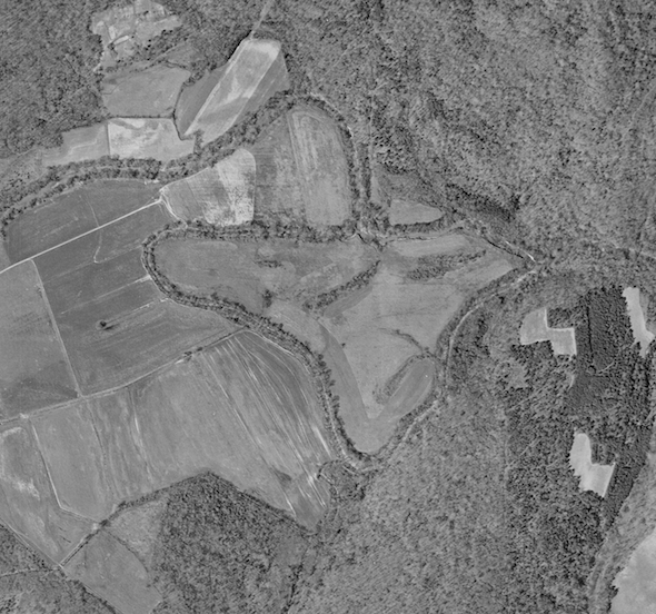
1938 aerial photograph of the bend with the canal clearly demarcated
Another theory would be that Cary Lumber Company, a group known to have clearcut the lands on the south side of that part of the river in the 1920s (the former Ruffin family lands), might have worked with the Collins family to coordinate a canal project that would allow the lumber company to float logs downstream (land transactions with the register of deeds show them purchasing and selling the land over a few year period).
However, this also seems unlikely, given that the Cary Lumber Company had its lumberyard to the south near downtown Durham, and floating logs down the Eno would eventually take the lumber to Raleigh. Not to mention that a flood event would be needed to lift the logs out of the shallows, and the logs would get stuck just as easily at Penny's Bend as they would at the bend a quarter mile upstream.
In an aerial photograph taken in 1938, you can see the canal clearly in place. This shows that the canal existed before the survey (plat map) that was made in 1942 and uses the first documented reference to a "canal" on that site. Close examination of the aerial photograph shows that most of the riverbank around the natural channel of the river has trees lining the waterway; the channelized area, however, has trees on the north bank but lacks trees on the south bank of the channel, suggesting to my untrained eye that laborers or equipment might have accessed the river in that area. My working theory would be that the canal project was undertaken during the depression years of the mid-1930s when CCC workers undertook many projects in the Durham County area.
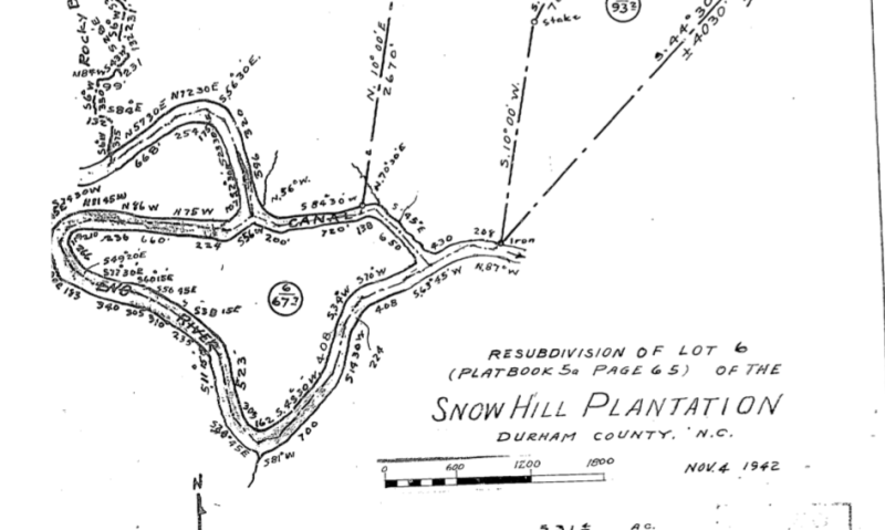
1942 survey (plat map) showing the channelized portion of river, called "canal"
We have documentation from the late 1930s, for example, that WPA workers re-channeled a portion of Ellerbee Creek where loopy bends were creating havens for disease-carrying mosquitos. It's possible that this loopy bend of the Eno River received a similar treatment, but the Durham newspapers and the WPA files do not contain any reference to the project. A more likely candidate might be the crew from CCC camp SCS-114 (founded in 1935), a base that was part of the Soil Conservation Corps and did work on local farms (using newly-acquired heavy equipment) to prevent soil erosion. At this loopy bend in the Eno River, it's possible that flooding was making it difficult to farm the cleared land without losing crops and soil, so the canal might have served to reroute the water to flow downstream in a way that made the feel better for farming (the aerial photograph, to my eye, suggests it was at least cleared, if not plowed). With most of the water flowing through the canal, the former channel is easy to cross (particularly on the west side).
The problem with the CCC camp SCS-114 theory is that most of the camp's records are missing. The National Archives in Atlanta, responsible for most of the federal CCC/SCS collection, has a document that suggests the camp did erosion control projects on over two hundred farms in the Durham County area. When I looked through these records, project plans for only two of these farms could be found at the Atlanta archive, suggesting that most of the project plans have gone missing. I would like to think that the answer to the riddle of the Eno River Canal might be in those lost files; I would also like to know if any residents still living in Durham County have ancestral memories of the origins of this canal. I have worked hard to try and solve this historical riddle, but little concrete evidence has yet turned up (including in the Durham newspapers of the 1930s, which I have scoured to little effect). The names of the people who ran CCC camp SCS-114 can be found, as well as the names of the gentlemen who ran local erosion control efforts for Durham County. I have not been able to find paper trails for any of these people yet, and I can dig up and submit their names here if it would help other historians follow leads to the answer.
I'm posting all of this because I am looking for partners to help me find the right people to ask. Perhaps families who did tenant farming on the Collins land (Henrietta Collins, the owner during the 1920s and 1930s, lived in Hillsborough and did not farm the land herself) would have ancestral memories or leads? In the Cameron-Collins papers at UNC Library, I cannot find any business contracts between Henrietta and any tenant farmers, so I don't know the names of the people who rented or farmed her lands on this southern side of Snow Hill Plantation in the 1920s and 1930s. The last theory I have heard– and one that I do not find quite persuasive– would be that the canal (or stretch of re-routed channel) formed naturally due to flood events and erosion and wasn't documented until it was deep enough to be of note. Since European colonization, this has not happened to any other section of the river, and I have hiked and kayaked through the channelized section. To my eye, the only similar area of the river would be the canal that was dug in the river at Gold Park in Hillsborough at the behest of a mining company (Piedmont Minerals); this area looks quite unnatural, and the work was done in the 1960s/1970s, rather than in the 1920s/1930s. I cannot at this stage agree to a theory that the canal formed naturally, and I invite anyone with leads to please leave a comment here and lend a hand!
For anyone who has read this far, thanks for entertaining these inquiries and theories. I can provide footnotes and links for the many claims laid out here; I have been researching the Eno River for a couple years now, so most of the details simply need to be dredged up from my mountains of notes. Thanks!
Add new comment
Log in or register to post comments.