Support OpenDurham.org
Preserve Durham's History with a Donation to Open Durham Today!
OpenDurham.org is dedicated to preserving and sharing the rich history of our community. Run by our parent nonprofit, Preservation Durham, the site requires routine maintenance and upgrades. We do not ask for support often (and you can check the box to "hide this message" in the future), but today, we're asking you to chip in with a donation toward annual maintenance of the site. Your support allows us to maintain this valuable resource, expand our archives, and keep the history of Durham accessible to everyone.
Every contribution, big or small, makes a difference and makes you a member of Preservation Durham. Help us keep Durham's history alive for future generations.
Comments
Submitted by Anonymous (not verified) on Thu, 7/16/2009 - 1:45pm
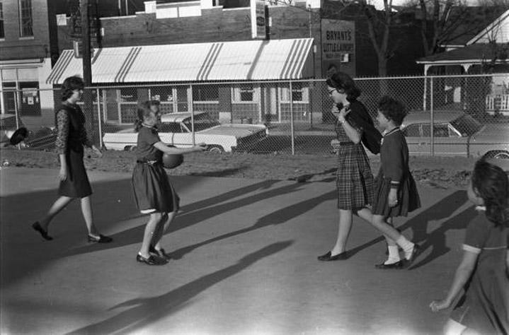
There's also a "Royal Ice Cream" sign (obviously not the same building as the site of the sit-ins though)
Submitted by Anonymous (not verified) on Thu, 7/16/2009 - 1:47pm
Note: you can see the "Royal Ice Cream" sign better in this view:
http://dc.lib.unc.edu/cdm4/item_viewer.php?CISOROOT=%2Fbarnes&CISOPTR=430&DMSCALE=100.00000&DMWIDTH=600&DMHEIGHT=600&DMMODE=viewer&DMFULL=0&DMOLDSCALE=25.04174&DMX=0&DMY=0&DMTEXT=&DMTHUMB=1&REC=6&DMROTATE=0&x=51&y=50
Submitted by Anonymous (not verified) on Thu, 7/16/2009 - 2:27pm
No leaves on the trees, sweaters they are wearing....surely not summer of '64 as labeled in the UNC link. I think the photos are not identified correctly.
I don't have a clue where this was taken-if in Durham.
Where would a fenced playground area be? Is it even a playground-I don't see swings etc. ? School? Church? City park? The cement block building looks a bit municipal but not fancy. I tried to see if there was a uniform theme with the plaid that a couple of girls were wearing.
??
Submitted by Steve (not verified) on Thu, 7/16/2009 - 4:50pm
Hmmm... the Barnes collection says that the photos were taken in the 2800 block of Lawndale, between Golf Street and Hillsborough Road. This image: http://dc.lib.unc.edu/cdm4/item_viewer.php?CISOROOT=/barnes&CISOPTR=429…
shows a slightly different view.
The 1960s images don't seem to jibe with the housing style(s) that are at the intersection of Lawndale and Hillsborough, plus if you look in the background of the pic posted on ED, there appears to be somewhat of a hill with a structure on it. And, this photo: http://dc.lib.unc.edu/cdm4/item_viewer.php?CISOROOT=/barnes&CISOPTR=441… seems to show a possible smokestack or two in the background.
Submitted by Toby (not verified) on Thu, 7/16/2009 - 6:43pm
Based on the apparent time of year (NOT summer) and the angle of the afternoon shadows, I'd say that street runs northwest-to-southeast, not east-west as Lawndale does.
Submitted by Toby (not verified) on Thu, 7/16/2009 - 7:34pm
Note the radio/tv tower with guy wires in the background of this shot (over the volunteer's right shoulder) -- http://dc.lib.unc.edu/cdm4/item_viewer.php?CISOROOT=/barnes&CISOPTR=424…
Anyone know where in Durham such a tower might have been in the mid-1960's?
Submitted by durmite (not verified) on Thu, 7/16/2009 - 7:43pm
I believe that the photo was taken in the Few Gardens area along Alston Ave., near Morning Glory Ave. The tower possibly is the radio tower located at the old Farmer's Exchange site just northwest of Holloway St and Alston Ave.
Submitted by Anonymous (not verified) on Thu, 7/16/2009 - 7:49pm
Could be the EK Powe playground, looking South onto Green Street. The height of the playground above the street looks about right and the chain link fence around the school and the blacktop pavement look almost identical to the ones I knew going to Powe for 5 years in the 1980s. Was if there was actually a commercial strip on the South side of Green? I'm sure some earlier aerial photos could answer this.
Submitted by Keith (not verified) on Thu, 7/16/2009 - 7:57pm
I have a 1964 Durham GTE/Telephone book at home and will have to look up Bryant's Little Cleaners and see if it is listed in the book's Yellow Pages.
Submitted by David N. (not verified) on Thu, 7/16/2009 - 9:34pm
Some observations, based on the whole series of photos:
Time possibly late afternoon, autumn. Road in front of the commercial buildings runs north-south (or possibly NW-SE, as Toby suggested), with the "playground" on the west side of the street. Structure to north is cinderblock and may be corner lot; to south and west of location are more houses. Across street to east is the retail building; north of it(what would be the SE corner of an intersection with a cross street) is a two(?)-story commercial building; to the south are more houses.
The two "smokestacks" are NE of location; antenna is east and slightly south. The terrian appears to slope down to the north and east (which suggests to me Neuse rather than Cape Fear side of Durham).
The "playground" looks like it may be a cement slab foundation. The cleaner's sign on the side of the building may just be an advertisement, not the location of the cleaners.
Submitted by Michael Bacon (not verified) on Thu, 7/16/2009 - 10:14pm
Based on nothing more than topography and hunches, I keep coming back to the area around Lakewood and South St. or S. Roxboro. No idea if buildings like this existed around there at one point.
Submitted by robby (not verified) on Thu, 7/16/2009 - 10:14pm
That could be the WSSB tower on Nixon st off Alston ave.
Submitted by Anonymous (not verified) on Fri, 7/17/2009 - 12:51am
How about South Driver St near the Old Y.E. Smith School?
Submitted by durmite (not verified) on Fri, 7/17/2009 - 3:55am
That's not the old Y.E. Smith School on Driver St. The playground was in the rear of the property along Guthrie Ave. between Hart St and E Main St. The only store (Irene's) was located next to the NE corner of the property, close to E Main St.
This "Mystery Photo" is a good one!
Submitted by Anonymous (not verified) on Fri, 7/17/2009 - 12:45pm
If you remove the awning from that strip, which likely will have happened...does that glass block resemble something on Mangum? and the house right next door resembles something on mangum too...hmmm
the playground may not even be a school...may be a church. I can't tell if any of the businesses are open, but girls are in dresses...
TSQ75
Submitted by Lynn (not verified) on Fri, 7/17/2009 - 1:20pm
"I can't tell if any of the businesses are open, but girls are in dresses..."
That means nothing except they're girls. I'll remind folks that females in Durham (County) schools were not allowed to wear pants to school until 1970, and even then -- no jeans!! Jeans for girls were allowed soon after, maybe '72?
I suspect that, wherever these photos were taken, it's long gone now. Probably a parking lot somewhere. :>
Submitted by Robby (not verified) on Fri, 7/17/2009 - 7:59pm
I checked in the 1963 telephone directory and found Bryant's little laundry at 905 1/2 Angier. Checked the city directory and Evans restaurant was next door at 903 1/2
This was near Elm st.The playground might have been a city park near the Colonial Store.
I looked at other photos in the set and the old church might have been Angier Av Penticostial Holiness Mission
Submitted by Erik (not verified) on Fri, 7/17/2009 - 8:40pm
I think we have a winner! Check out the Streetview - the house at the right side of the photo matches perfectly and if this location is correct, where the "playground" used to be is now an open field that is raised somewhat from the street and has an old set of stairs next to the sidewalk.
Check it out: http://maps.google.com/maps?f=q&source=s_q&hl=en&geocode=&q=905+angier+…
I love that this is in the neighborhood that the author of this blog does a lot of his work!
Submitted by Gary (not verified) on Fri, 7/17/2009 - 9:50pm
Indeed, I think Robby has nailed it. Although I don't have great aerial/Bird's Eye shots of that corner, I can tell enough from them to confirm that the playground must have been part of the Edgemont Community Center, located on the southeast corner of Elm and Angier. The two story building on the left in the background was located on the northeast corner of Elm and Angier. Various other shots people have linked show the stacks of Durham Hosiery Mill No. 6 in the background with the woman/children standing in front of the community center.
Nice work!
GK
Submitted by Anonymous (not verified) on Sat, 7/18/2009 - 1:29am
So, Gary-
When you find misidentified photos on other site, do you notify the owner of that site or poster?
Seth
Submitted by Anonymous (not verified) on Sat, 7/18/2009 - 1:32am
Good sleuthing, guys.
So, Gary, was this erased in urban removal(renewal)?
Submitted by Toby (not verified) on Sat, 7/18/2009 - 4:31am
Nice going, team!
Coupla comments:
- It appears that section of Angier Ave. must have been made narrower or moved to the southwest a bit since the photo was shot. In the photo, the house with the Queen Anne trim on the porch was much closer to the street.
- It makes me oddly elated that there is a "Toby St" right next to this spot.
- I posted a note to the webmaster for the Billy Barnes collection at UNC, with a link back to this ED post.
Submitted by Steve (not verified) on Sat, 7/18/2009 - 4:29pm
Very cool! Great work everybody!
Sometimes, it takes a village...
Submitted by Anonymous (not verified) on Mon, 7/20/2009 - 11:40pm
For sure this is the Edgemont Community Center on the corner of Elm Street and Angier Ave.I played there as a kid and don't remember what year it was built. But I do know you could take cooking lessons and play games inside and out.You felt safe and cared for.
Duke University sent students there to do different activities with all the kids.
Across the street was Bryant's Little Laundry,Wiley Evan's Cafe in the middle and Brame's Speciality Co. on the corner.
Add new comment
Log in or register to post comments.