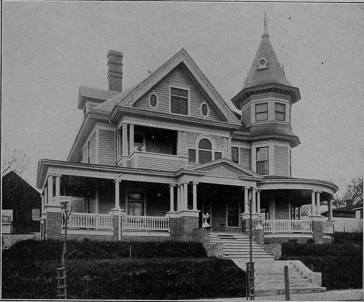
1903 - noted as "successful remodeling of an older home" (Colonial Southern Homes by Barrett, Charles W.) Retrieved from https://archive.org/details/colonialsouthern00barr)
The northernmost portion of McMannen Street transitioned from residential to commercial use early on - certainly by the late 1800s. This included the Peerless Flour / Austin-Heaton company and the Kramer tobacco prizery.
The early houses along the portion of McMannen St. south of the commercial area were occupied by names that would become familiar in Durham: Cheek, Wilkerson, Mangum, Angier among them. As mentioned yesterday, many of these houses were supplanted by larger, more ornate structures in the 1890s-1900s.
There really is no written history of McMannen St. as neighborhood that I've come across.
412 McMannen Street appears to have been built by WT Carrington, president of Pope Carrington Co. and Carrington Cigar Co. In 1915, J. Cheatham Carrington, president of the Carrington-Rogers Drug Co. and WT Carrington's widow, Nannie Carrington, lived in the house.
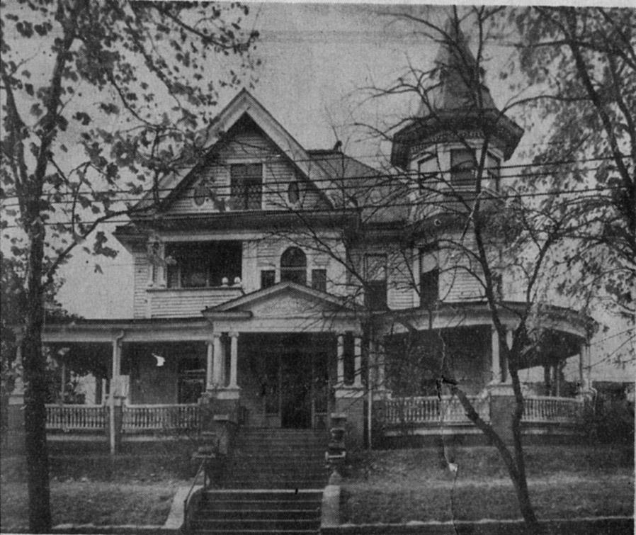
Most of McMannen Street transitioned very quickly, very early in the 20th century to rooming houses and apartments. It never seemed to form a distinct identity, and it doesn't stand out in the mind of many folks I've interviewed, despite the grandeur of houses like this.
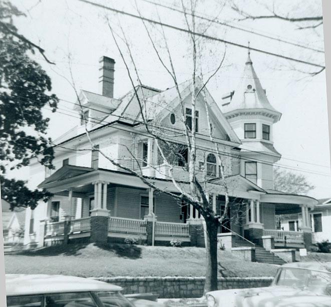
1953
Interestingly, and indicative of how a house like this was viewed by mid-century, the photo above from 1953 is from a Durham Builders Supply advertisement, in which it is compared unfavorably with 2021 Woodrow Street, titled "Old" with 2021 titled "New" - the subtitle reads: "Helping to building a BETTER Durham since 1929."
By the time of the urban renewal appraisal photos, it is clear, though, that many of these houses were still impressive and well-maintained.
412 S. Mangum, 1966
By the late 1960s, all of this land was cleared by the City of Durham using urban renewal funds. The language of the urban renewal appraisals is rather extraordinary - the word "obsolete" figures prominently. "Functional obsolescence", "no remaining useful life", "unsuited to best use of land, which is commercial", etc. In a way, I'm impressed by the honest verbiage, even while I find it incredibly regrettable and foolhardy. But we do similar things today - just hidden behind language, other ostensibly noble purposes, etc.
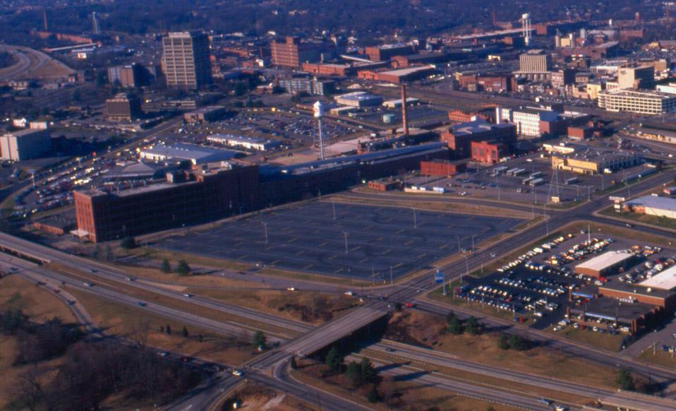
The area became another vast wasteland of surface parking.
Looking west, 1989.
(Courtesy Durham County Library)
02.01.89
(Courtesy Herald-Sun)
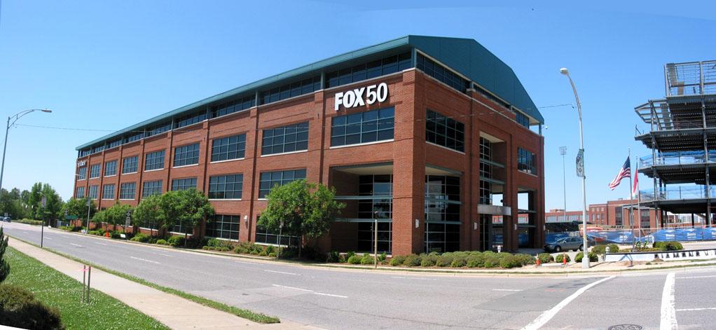
Subsequent to the construction of the Durham Bulls Athletic Park, Capitol Broadcasting bought some of this frontage (corresponding to about the middle 2/3 of the 500 block of S. Mangum above) and built the Diamond View building - begun in 1997 and finished in 1998.
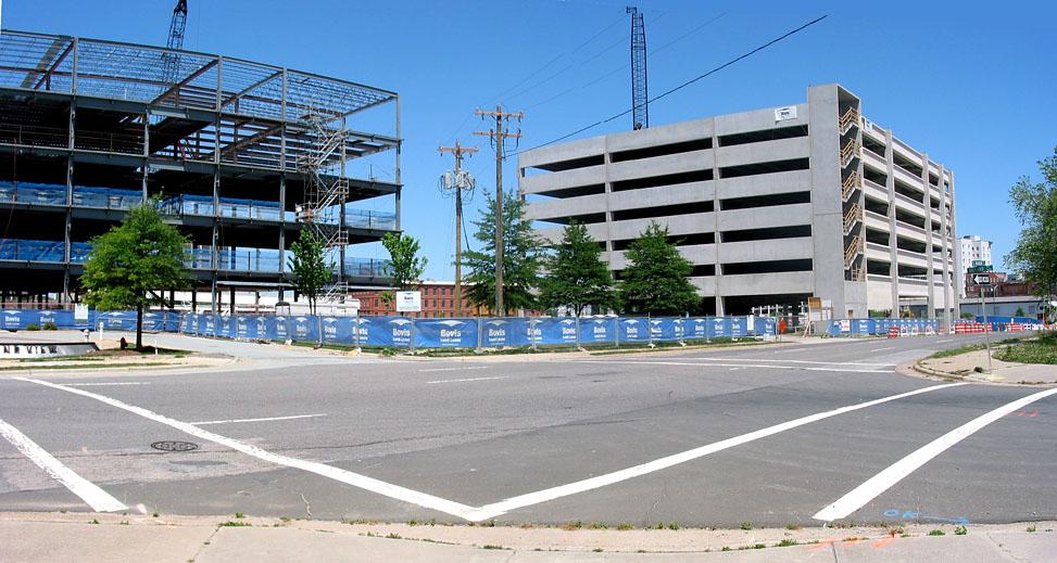
Most recently, Capitol has begun the Diamond View II building, and the city has begun the Performing Arts Center.
Diamond View II and the parking deck of the Performing Arts center, looking northwest.
Diamond View I, looking southwest.
I've documented my thoughts on the design of the Performing Arts Center previously, and I would say, at this point that it appears both better and worse than I expected. On the plus side, I hadn't appreciated how the curve of South Mangum would make the front of the PAC a great terminating vista as one crosses Parrish St. heading south through downtown on Mangum. On the minus side, the decision to stick the parking deck as a long, continuous frontage along Mangum is just bad. As one drives down the Durham Freeway, the skyline of Durham has become - DV I, big parking deck, jail.
Beyond that, though, I come back to my ongoing focus on the pedestrian. South Mangum St. is no place for pedestrians, and nothing that Capitol has done / is doing or the city is doing will improve that. Yes, it's complicated by the fact that it's a state road - and NCDOT hates pedestrians. But would someone - anyone - in this city hire an architect who will build a new building that has a pedestrian-scale, active street frontage. This is not that complicated, and there are (still) a bevy of old buildings around to use as a template to understand this. Here are a few things to get you started.
Blank walls = bad
No entrances on the street/sidewalk = bad
Lack of fine-grained surface detail = bad
Long, horizontal windows = bad
I wouldn't expect someone to look at the beautiful houses that were here and try to rebuild them, or imitate that style. But respect the elements of those houses that makes it appear that McMannen St. was, at one point, a pleasant place to walk.
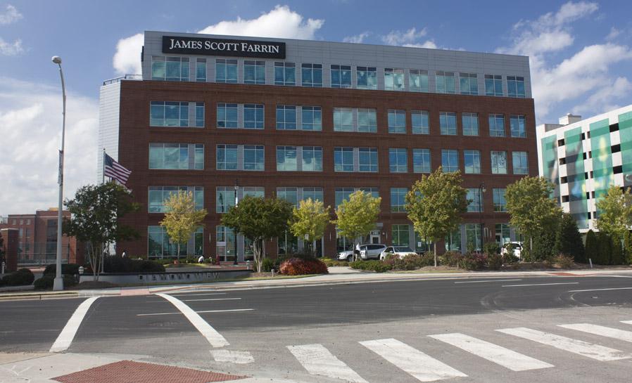
Diamond View 2, 10.27.10. The parking lot in front is the site of 412 McMannen.
Comments
Submitted by Anonymous (not verified) on Fri, 6/15/2007 - 4:07pm
Gary, the don't get it. That is the problem. If it wasn't for Struever Bros., they probably wouldn't have lined the other sides of the new deck with buildings either. American Tobacco is a beautiful development, but it is a failure when it comes to urban design. The parking decks are huge and lifeless blocks that jut out into the street (in the case of Carr St, closed the street altogether for no good reason). You would never see that in a city that did "get it." I was shocked to learn how many of Durham's most progressive designers had a hand in planning AT's site plan.
A book on basic principles or urban design should be required reading for anybody who works for the City and County or who is elected to office.
Submitted by Michael (not verified) on Fri, 6/15/2007 - 7:06pm
Just to clarify something that I've been a little confused about: The big concrete superstructure that's there now is the new parking deck, not the PAC, right? I haven't had enough time to go by there (it's awfully hard to drive by slowly and take a look), but if I'm remembering the site plan right, the PAC will rise where there currently appears to be little other than a mudpit.
Could someone either verify this or correct me if I'm wrong?
Submitted by Gary (not verified) on Fri, 6/15/2007 - 8:45pm
Anon
Agree completely - I can't get over the useless closure of Carr St. Why would you worsen connectivity along one side of a two-block long 'superblock' (AT)? There is obviously a strong push to seal off developments, internalize them, etc. The picture of DV-I above is most telling to me. The front entrance of the building is ~8 ft from the sidewalk but does not connect to the sidewalk. Why? It connects to the circular driveway. Would it be so incredibly terrible if there was a connection to the sidewalk?
Michael
You are right. What is being built right now is the parking deck that will be to the south of the PAC. I'd put the parking deck in the middle of the block and put the buildings around it - making a wide-sidewalked streetscape as public space. They are putting the decks on the outside and a plaza on the inside - walled off from the traffic and sidewalks (hidden away from the public right of way). The amusing thing is how similar these designs are to the design that nearly destroyed downtown - big circulation loop with parking just inside and a (never realized) pedestrian-mall Main St. in the middle. Somebody please tell someone this creates isolated pockets of activity, not a city.
GK
Submitted by Anonymous (not verified) on Fri, 6/15/2007 - 9:15pm
Such a shame those homes are now gone. Those houses must have been something in their day. It would have been so cool for them to still be around and restored.
I’ve been reading this blog for awhile now, and have wanted to say thank you for doing it. I’ve really enjoyed reading it, although at times it can be disappointing to see some of the changes that destroyed many beautiful buildings.
I really enjoy all of your posts about East Durham. My mom grew up there until her family moved to another part of town in the 1960s. Are you planning on profiling more of that area? They lived on Ramseur St and their house was torn down at some point.
Thanks again for a great blog!
Submitted by Michael (not verified) on Fri, 6/15/2007 - 9:30pm
Couple of things about the positioning of the current deck and Carr St. Carr St.'s an odd case, because in reality, the street is pretty much still open. Its right-of-way continues uninterrupted all the way through to Pettigrew, and only has visitor parking on either side. There's no gate there or anything else to keep you from happily driving down it.
Of course, if it had remained OFFICIAL right of way in Durham, they never could have put angle parking in there. I don't mind the street being covered up by parking in places -- I think it can be kind of cool -- and I'd prefer it if the signage actually indicated that it was a continuation of Carr St., but it's not as bad as it could be.
Regarding the deck, thanks for the clarification on that. The word I heard from Phil Szostak on that was that the original plan was to wrap the deck on all sides, but that they simply couldn't convince anyone that they were going to be able to sell those spaces along Mangum, what with the freeway out the front door and the jail across it. So in order to maximize the usable space, they lumped the deck over on that side and kept everything else on the other side.
Submitted by Gary (not verified) on Fri, 6/15/2007 - 10:11pm
Michael
Would that Carr St. actually functioned that way, no one except the most savvy is going to drive through a parking deck, particularly since it isn't a continuation of the street, but rather offset by a full-street width. Thus, what you see if you entered the deck from Pettigrew is the 'dead end' fence of University Ford, not a continuing streetscape down Carr.
Yeah, I'm sure no one would buy anything on Mangum - oh, wait, except Capitol, and Scientific Properties. Dimwits.
GK
Submitted by Gary (not verified) on Fri, 6/15/2007 - 10:12pm
Anon
Thanks so much. I do plan to do more of East Durham in the coming months.
GK
Submitted by Christopher (not verified) on Thu, 1/21/2010 - 8:56pm
While the whole concept of Urban Renewal is obviously, badly flawed, I still wonder what in particular they were trying to accomplish here. I know it was used as a tool to rid the city of some "troublesome" disadvantaged areas, especially where the population was in an easy-to-marginalize group, like much of the housing in Hayti. But aside from a few outliers like 510/522, most of these homes still seemed well cared for and in good shape--412 and 520 in particular were fantastic Queen Annes. Did they honestly believe that arbitrarily bulldozing an entire neighborhood that still had value as such would magically attract new development? Especially when you leave behind only commercial/industrial structures, in a city that already had a surplus of available such space? Hard to fathom...
Submitted by De-Jo712 on Tue, 2/21/2023 - 1:09pm
I lived next door to this beautiful house back in the 50’s , it was the home of a prominent Doctor. As kids we thought of it as a castle.
Add new comment
Log in or register to post comments.