Support OpenDurham.org
Preserve Durham's History with a Donation to Open Durham Today!
OpenDurham.org is dedicated to preserving and sharing the rich history of our community. Run by our parent nonprofit, Preservation Durham, the site requires routine maintenance and upgrades. We do not ask for support often (and you can check the box to "hide this message" in the future), but today, we're asking you to chip in with a donation toward annual maintenance of the site. Your support allows us to maintain this valuable resource, expand our archives, and keep the history of Durham accessible to everyone.
Every contribution, big or small, makes a difference and makes you a member of Preservation Durham. Help us keep Durham's history alive for future generations.
Comments
Submitted by Anonymous (not verified) on Sat, 7/28/2007 - 3:27pm
Wouldn't it be great if the city /county could make these old rail lines into biking /walking trails? Our reliance on the car would decrease as would the need for excessive surface parking in the city center, and the quality of life in the downtown neighborhoods would improve. I suspect this type of initiative would have broad support in the Durham community.
Submitted by Anonymous (not verified) on Sat, 7/28/2007 - 5:48pm
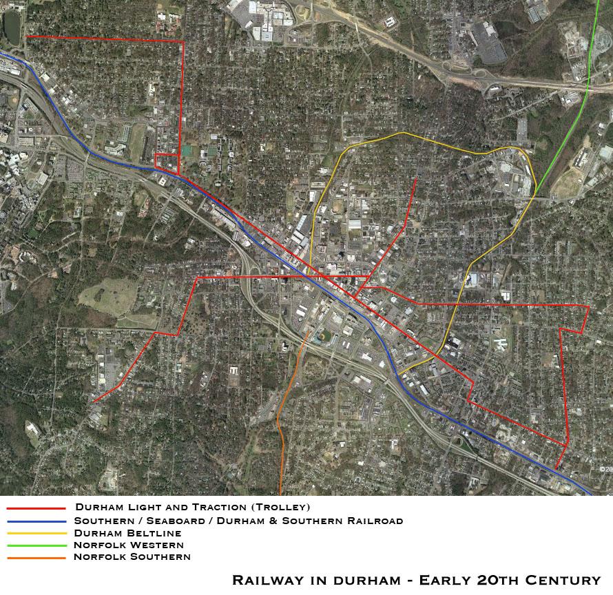
I have a question...What exactly was the Beltline? Was it another trolley or railroad? I've never heard of it before. Thanks!
Submitted by Phil (not verified) on Sat, 7/28/2007 - 7:25pm
An inspiring post for imagining what used to be and what today would be like if there were still trolleys running those same routes.
Also, other readers may wonder, "how did Gary make such a cool graphic?" I can't answer that question, but today's NYTimes has a related article on "everybody a cartographer", here at: http://tinyurl.com/26se4g
Submitted by Sean Wilson (not verified) on Sat, 7/28/2007 - 10:53pm
anon 1 -
Rails-to-trails is a great idea, and I believe that's the plan for some of these old lines. More here:
http://www.triangletrails.org/COMBINED.HTM
Norfolk-Southern does not appear to be eager to let these lines go. I'd love it if it were to happen -- I'm looking at a commercial opportunity that opens its doors to one of these old railways.
Submitted by Gary (not verified) on Sun, 7/29/2007 - 2:41am
Anon1
The orange Norfolk-Southern line is now the American Tobacco Trail. The city has been trying to negotiate with Norfolk Southern to buy the Beltline and the NS line up to Roxboro to turn them into rail-trails.
Anon2
The Beltline was railroad, and sort of an intracity freight line that allowed the train to load and unload through several industrial areas - really key in pre-truck days, since not everyone could locate on the main line. I'm not sure when it was abandoned, but you can easily see these tracks near West Village/Five Points (crossing main and morgan). It's also the railroad bride crossing Trinity near Washington, and the railroad you cross heading north or south on Roxboro or Mangum, respectively. See the link that Sean posted above.
Phil
Thanks - wouldn't it be cool to hop the trolley from Golden Belt to 9th St.? Other than the shot from Google Earth, I used the archaic Photoshop to draw the map. Cool article - thanks for the link.
Sean
Very cool = thanks for posting the link. I think the Beltline, including the part extending south to Golden Belt, would be a serious boon for our in-town neighborhoods.
GK
Submitted by Anonymous (not verified) on Sun, 7/29/2007 - 10:59pm
Thanks for answering my question, and I always wondered about those tracks I've seen on Washington St. and on the Avondale Bridge!
Submitted by Joe (not verified) on Wed, 8/1/2007 - 4:57pm
One of the nice things about turning those tracks into trails would be that they're very level, although they might twist and turn somewhat. It can make walking easier if you have to walk a long way.
I've walked the beltline from near American Tobacco clockwise to Glendale Ave. I'm surprised that the railroads haven't lost title to some of the land, or at least wind up with easements all over the place. Somewhere near Orient St., there was an entire couch sitting on the tracks, as if someone wanted to sit there and look south down that section. That section was also particularly overgrown. It's even worse now.
I'd particularly like it if the beltline became a trail: the beltline is a loop, where as the entire current structure of Durham's trails is (AFAIK) a tree. This may sound odd, but if I go out for a walk or a bike ride, going in a loop is more appealing then walking to the end of a trail and turning around. I guess it has to do with not seeing the same stuff twice, but I'm not sure.
BTW, my favorite crazy idea: turn the disused rail lines in Durham into some sort of Segway track. :)
Add new comment
Log in or register to post comments.