Support OpenDurham.org
Preserve Durham's History with a Donation to Open Durham Today!
OpenDurham.org is dedicated to preserving and sharing the rich history of our community. Run by our parent nonprofit, Preservation Durham, the site requires routine maintenance and upgrades. We do not ask for support often (and you can check the box to "hide this message" in the future), but today, we're asking you to chip in with a donation toward annual maintenance of the site. Your support allows us to maintain this valuable resource, expand our archives, and keep the history of Durham accessible to everyone.
Every contribution, big or small, makes a difference and makes you a member of Preservation Durham. Help us keep Durham's history alive for future generations.
Comments
Submitted by Phillip (not verified) on Mon, 9/24/2007 - 12:57am
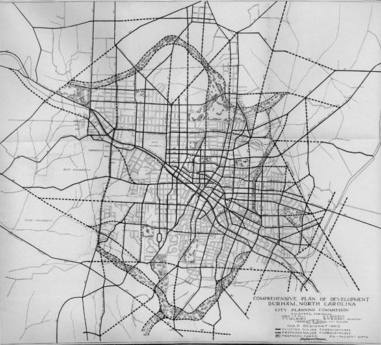
Wow, those greenbelt parks really are interesting. At first, I just assumed the northern one was following the Eno, but the Eno is not even on the map... that's the Ellerbee Creek. I would love to know what happened to the plan -- what, if any of it, was put into place.
Submitted by Anonymous (not verified) on Mon, 9/24/2007 - 10:16pm
Did you notice that Rocky Creek and Duke Park are included in the plan? I wonder if the existed or were still being planned in 1927?
Intersting closing of the loop considering your "parks" study focus groups.
Jon
Submitted by Michael Bacon (not verified) on Tue, 9/25/2007 - 6:22pm
Ah ha! Just as I suspected! The original plan was to connect University Drive, across the old American Tobacco Railroad, to be contiguous with what is now Lawson St., and actually make it connect with, you know, a university.
Now let me sit back and see if I can think of a reason why someone might have objected connecting the Forest Hills area with North Carolina College for Negroes, quite literally, just across the tracks. Hmm....
Submitted by Toby Berla (not verified) on Thu, 1/22/2009 - 9:52pm
In terms of the northern greenbelt park in the 1927 plan, quite a bit of it is still green space, but (as is typical) it is not connected.
Starting from the eastern end of the crescent-shaped belt: Duke Park comprises a small part of what was to be a giant anchor park -- the squiggle of Knox St and Knox Circle are a good way to orient a Google map for comparison. A few blocks west on Knox, the North-South Greenway bike trail also correspond to the old plan. North of I-85, Northgate Park and the unbuilt areas south and north of it. Then Rock Quarry Park.
The anchor park that would've been at the western end of the northern greenbelt is now Hillandale golf course and the reservoir. East of there is ECWA's 17-Acre Wood. Crossing Guess Rd, there is some open land between Forest Rd and Garland St, all the way up to I-85. Unfortunately, north of I-85, around North Pointe shopping center, the creek bed is nearly paved over. There is quite a bit of unbuilt land north of there, between Broad St, Stadium Dr, and Duke Homestead Rd.
Wouldn't it be cool to try to patch together a walking path along the entire length of Ellerbe Creek?
Submitted by Toby Berla (not verified) on Wed, 5/20/2009 - 3:58am
As it happens, the Durham Open Space and Trails commission (of which I am a relatively new member) already has a proposal to create the West Ellerbee Creek Trail Extension, which would complete quite a bit of the western end of the north-side greenbelt. Details here (pdf):
http://tinyurl.com/qr8fa2
Add new comment
Log in or register to post comments.