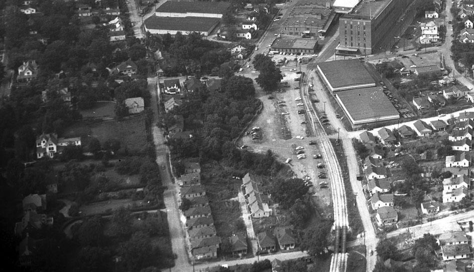
Looking north up Willard St., 1950s.
The unnuanced view of urban renewal was that it was perpetrated by one group or another for a singular reason - a racist motive, a profit motive - all recognizable themes that are easy to believe.
The truth is, of course, much more complex. Like many broad sweeping changes, individual groups believed the singular action of urban renewal would solve the particular problem that was important to them; the problem was that urban renewal simply could not solve all of these problems, and it created enough problems to ensure that many people's aspirations would not be met.
The most underreported, and likely most pivotal, group involved in urban renewal, were in fact the idealists who thought that they were saving people from poverty and ignominious living conditions. Willard St. is, to me, an interesting case study of the kind of situation that would have motivated this group.
Willard St. changed character significantly as one went south from the railroad tracks and West Chapel Hill St.; mansions gave way to fine homes, to modest homes, and, eventually, after crossing Morehead Ave., shacks. This followed the classic economic segregation by elevation trend - Willard south of Morehead descended into the lowlands along Third Fork Creek. It also provided easy access to jobs in the expensive mansions of Morehead Hills - a mere block away. Strongly disparate economic conditions in close proximity was far more the norm in the pre-auto era. Of course, the overlap between race and economic status meant that African-Americans were the majority occupants of these houses.
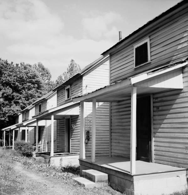
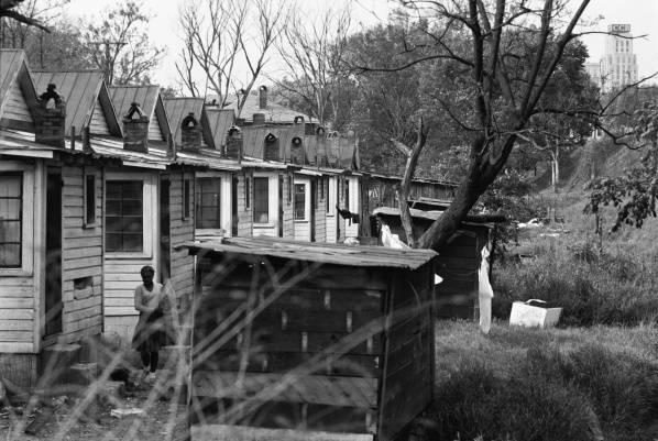
When these were catalogued by photographer Billy Barnes in the 1960s, you can see the kind of conditions these houses presented.
Looking northeast from Willard, 1960s.
(University of North Carolina)
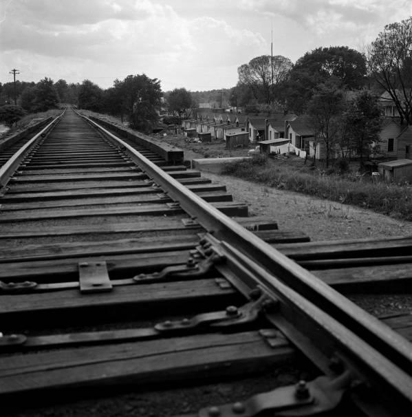
Looking southwest from the tracks (now the ATT), 1960s.
(University of North Carolina)
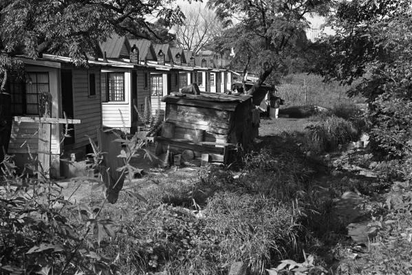
Looking north at the rear of the houses on Willard, 1960s.
(University of North Carolina)
Looking north at the rear of the houses on Willard, 1960s.
(University of North Carolina)
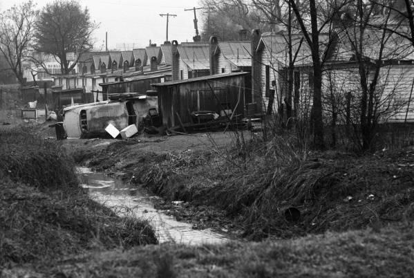
Looking south at the rear of the houses on Willard, 1960s.
(University of North Carolina)
You can understand that a segment of people, fighting the "war on poverty" and determined to save people from a threat to public health - would want to destroy this kind of housing and provide public housing in places like Few Gardens - clean, modern, with water, sewer, and electricity.
This more than anything was the justification that allowed the program to be implemented - and used to clear away anything that might stand in the way of somebody's idea - be it a freeway, a new city hall, cul-de-sacs, etc., etc. Somehow the door-opening culpability of those seeking social change through landscape change was lost in the aftermath.
Willard St. was cleared away by urban renewal - and has almost ceased to exist south of the Freeway. I'm not going to spill tears over the loss of these houses - like much of the housing to the east in the lowlands between Willard and Fayetteville, it was ramshackle.
Willard Street, itself is nearly gone south of the freeway - intersections with Lakewood and Morehead were elminated, and much of the roadway taken up.
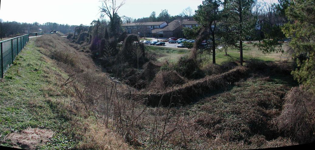
Looking southwest from the American Tobacco Trail, 2007. (The old Cobb St. bridge over Third Fork Creek - when Cobb crossed under the tracks as seen in the top picture - is in the foreground, covered with vines.)
A one block section of the street remains back here, accessible only from Cobb.
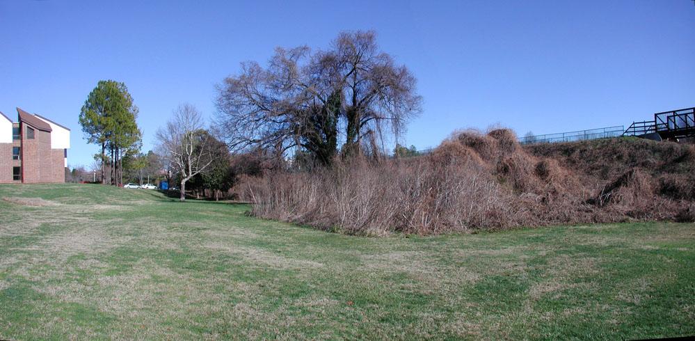
Looking northeast, 2007.
Most of the street has simply disappeared with the houses.
Looking northeast, 2007.

Comments
Submitted by Andrew (not verified) on Thu, 1/3/2008 - 1:55pm
The photo you've labelled "Looking north at the rear of the houses on Willard, 1960s." pretty much sums up the phrase "economic disparity". What a picture, juxtaposing these shacks with the visible CCB tower in the background.
--ASE.
Submitted by John Schelp (not verified) on Thu, 1/3/2008 - 3:53pm
Gary,
The time and energy you put into your entries is amazing. The time you took to walk around and take the present-day pictures, post alongside old pics and compile all this information is incredible!
We, and generations that follow, will see your work and be forever grateful for what you've created here...
According to Jean Anderson's book, "Durham County," when Durham's oldest neighborhoods were first established, white folks built their homes on hilltops and African Americans were left with the bottom-lands.
If you drive along Englewood Ave today (from Georgia Av in the west, to Avondale in the east), you'll go from Watts Hospital-Hillandale at one of Durham's highest points, down into Walltown, up to Trinity Park, down to Green/Ruffin at South Ellerbe Creek, up to Duke Park, down to Avondale.
Larger houses stand on the hilltops, smaller homes down in the bottom-lands. (Over the years, the street has "flattened out" a bit.)
The bottom-lands were less desirable because smoke from factories and cotton mills settled in low-lying areas where flooding was also a problem. Hilltops offered fresh breezes.
As shown in your photographs today, many of the smaller houses near creeks are gone. In some areas (like near Cobb and near Green & Ruffin), the low-lying shacks were replaced by apartment buildings.
Submitted by Gary (not verified) on Thu, 1/3/2008 - 4:48pm
Andy
Agreed- I'm wondering whether the structures behind the houses are actually outhouses.
John
Thanks for the kind words - always nice to hear, and of course the ongoing utility of this would be my greatest aspiration.
The interesting thing to me about the segregation by elevation is that I don't think racial segregation was the primary driver (although it certainly was a driver) - rather, I think economic segregation was the root. At a minimum, they were parallel and intertwined forces; the same economic segregation by elevation appeared in the African-American communities. The wealthy African-Americans built their large houses on the high elevations of the Fayetteville St. ridge (in Hayti) and the Kent St. ridge (in West End/Lyon Park) while the poorer African Americans were in the bottomlands to the east and west of Fayetteville, and south/west/east of Kent.
GK
Submitted by John Schelp (not verified) on Thu, 1/3/2008 - 5:04pm
Good point. Of course, Hayti and West End/Lyon Park are already at lower elevations.
When I bike from East Campus to RTP (passing West End and Hayti), it's mostly downhill.
Only when I get to the edges of RTP (on Cornwallis) does the road start to consistently rise.
Submitted by Gary (not verified) on Thu, 1/3/2008 - 5:17pm
John
Actually, not so. Fayetteville St. at St. Joseph's is, according to a quick look at Google Earth, 406 ft. Kent is also about 405 ft. Five Points is 389 ft. Cleveland St., a prototypical historic white and wealthy ridge, is 404 ft. Trinity Park is down in the bottomlands of ~382ft. :)
GK
Submitted by John Schelp (not verified) on Thu, 1/3/2008 - 6:06pm
Was describing my bike ride from East Campus to RTP.
I go down Buchanan, down Shepherd, down Morehead to the American Tobacco Trail, and down/along the old RR tracks/ATT to Cornwallis (where you can still see back-yard gardens straight out of your B&W photos).
You're right, though. To bike from down where Morehead Ave meets the ATT trail-head, up the hill to Fayetteville St, would be a struggle for many of us 45+ year-olds on a bike.
Now, future generations reading this blog will have something else to contemplate... ;)
Submitted by Old Democrat (not verified) on Sat, 1/5/2008 - 7:09pm
"The door-opening culpability of social change through landscape change".
I don't really remember it that way. Replacing the housing like that found on Willard St. was known as "slum clearance" not "urban renewal". Slum clearance was a major progressive cause from the 1930s on. Democrats were elected to Congress from the cities on the promise that they would bring in federal money to their districts to build modern housing. One of the commenters was wondering whether those were outhouses in the back of the Willard St. houses. I'm sure they were. They also got all their water from a handpump, hopefully in the kitchen but often also out in back.
"Urban renewal" came along in the late 1950s because the cities were losing population, commerce, and tax base to the suburbs due to the transportation revolution after World War II. The idea was to replace the capital investment that had gone to the suburbs. Some cities used the money well and others didn't.
These issues seem quite separate to me. I admire the "idealists" of that time. The idea of the government providing housing for anyone except wounded veterans was completely novel at the time.
Submitted by Gary (not verified) on Sat, 1/5/2008 - 7:49pm
OD
I'm sure it went by varying names at the time, but it was cleared as part of the Federal 2/3 - city 1/3 urban renewal program, as was most of Hayti. You are right that there were Federally-funded housing programs to create new public housing from Hoover onward. But clearance was never done on the massive scale of urban renewal. Blight clearance was a heavy part of the urban renewal justification - I have pored over the area assessments and individual housing appraisals from the mid 1950s to 1970, and the language repeats over and over.
Coupled with this in the program was the idea that what would replace the blight/outdated/outmoded infrastructure, housing, and commercial space would be shiny new cul-de-sacs, malls, etc. that would remake downtown in the image of the suburbs. This would stem the tide of economic flight to the suburbs. Any divorce between the two is ex post facto exculpatory dissociation.
My point isn't to say that the aim of those who wanted to improve the abysmal housing conditions that people had to live in was ignoble. How could you not want these people to have better housing to live in than this pit of despair?
The point is how implementing landscape change on a grand scale, with a particularly utopian vision is fraught with pitfalls and potentially dramatic repercussions, no matter how noble the intent.
It's also to say that while it's fashionable to call urban renewal racist/classist or similar (and it was) - resting on that easy explanation as the whole truth ignores the complicity of good intention in creating a racist/classist result. If we ignore that, in a rush to absolve ourselves and our good intentions, we risk repeating our mistakes.
GK
Submitted by Andrew (not verified) on Thu, 1/31/2008 - 3:06pm
I recently pulled a small volume about Orange Factory from the library (written by John Baxton Flowers, III.). Willard Street was apparently named for one of the more famous proprietors of the factory, William H. Willard.
He was a Massachusettes man related to Ralph Waldo Emerson and moved to NC when he was 21. By 1872, he was involved with both the Morehead Bank (which Gary mentioned here ) and had purchased -- with SF Tomlinson -- the RF Morris & Son Tobacco Company.
By at least 1887, Willard owned the north Durham-located Orange Factory. The whistle-stop station of Willardsville just east of the Orange Factory village was named for him. He died in 1898.
With the ongoing drought, I am planning to visit the Little Reservoir that swallowed the factory and see if the imposing structure has re-emerged.
Submitted by Bill Busa on Sun, 9/16/2012 - 2:07pm
In reply to I recently pulled a small by Andrew (not verified)
Andrew, please note that all of the old maps (well, all those of my acquaintance anyway) refer to the community and the depot as "Willardville", not "Willardsville", and the Durham County GIS system names the current street at its site (just outside Bahama) "Willardville Station Road". I am not sure when or how the mis-spelling (with an 's') came to be, but it is perpetuated today by Google Maps (which has one end of the short road named without the 's', and the opposite end named with it), reflecting, no doubt, the same difference in the physical street signs at the two ends of the road. It is, granted, a small matter, but one which is eternally annoying to those of us who live on this pleasant country road. There is no 's' in Willardville.
On a related note: does anyone have a good fix on the exact site of the old Willardville Station? No one I know who lives here does; I'm not sure anyone alive today can identify the site of Willardville Station. I've walked the N&S tracks across our property, and our neighbors', many times, looking for tell-tale signs (not an easy thing to do, given that here the tracks have been swallowed up by deep forest and voracious ticks), but no luck. The old maps I've seen aren't much help. Any pointers, however tenuous, would be greatly appreciated.
Add new comment
Log in or register to post comments.