The genesis of Durham as a town is most inextricably linked to the existence of the NW-SE ridgeline that runs through the Piedmont, separating the Cape Fear and Neuse River basins. As I've written about previously, this ridgeline is a natural transportation corridor, and settlement along the corridor was therefore no accident.
Within later-Durham's immediate sphere, Hillsborough and Raleigh were, by the 18th century, the established towns along the roadway that followed the ridgeline. This roadway was, not suprisingly, called the Hillsborough Road, the Raleigh Road, or the Raleigh-Hillsborough Road (or vice-versa) in this area. Journeys were not quick along these roadways, riding, walking, or being pulled by horses. There were, of course, scattered settlement and farms along the roadway, and such farmers could enjoy easier access to markets than those more distant from the main road. Other establishments for the itinerant traveller popped up along the roadway as well; I like to call these 18th/19th century 'truck stops'.
If that term has a somewhat pejorative ring to it, that's intentional. Perhaps long journeys just don't sit well with most folks, particularly if they are alone (or at least on 'business trips') but the seamier side of such places on the side of the highway today - that how-soon-can-I-wash-my-hands feel - is nothing new.
These settlements predated Durham (not the existence of a few stores and homes at the later site of Durham station, but Durham as city.) One well known 'truck stop' was Prattsburg, which I've previously written about. Located on the east side of later-Durham station, Prattsburg was well known for the main forms of vice available - drinking, fighting, gambling, and prostitution - not necessarily in that order. It also had more practical (depending on your point of view, I suppose) services, such as a blacksmith shop, store, cotton gin, etc. William Pratt, the owner, had the place in fine form by the 1830s.
Pratt also owned land west of later-Durham Station. Another, similar settlement was established here by the early 1800s, and named Pinhook. As a Trinity College historian so eloquently put it in a 1906 history that mentions Pinhook: "some questionable characters kept a resort there, and nearby there was a grog shop." The area contained a campground, a well, and grove of trees to rest horses in the shade as well as the gambling, fighting, and prostitution that seemed to be prerequisite. After Pratt, this land passed into the hands of William Turner, who held a license to dispense spirits at Pinhook in 1850, and eventually (by the time of the railroad survey) Andrew Copley. Jean Anderson surmises that Pratt was the likely originator of Pinhook, though, given his other associations with tawdriness.
Helpful to the business of Pinhook was also the establishment of the state university ~15 miles to the southwest. College students have changed less over the course of the past ~150 years than one might imagine.
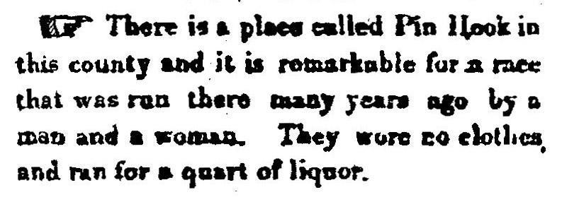
A story related in history collected by Duke professor John Spencer Bassett is a small news item that ran in the Hillsborough Recorder in 1871, without additional explanation:
Scan from the original Hillsborough Recorder, 1871.
(Courtesy of David Southern)
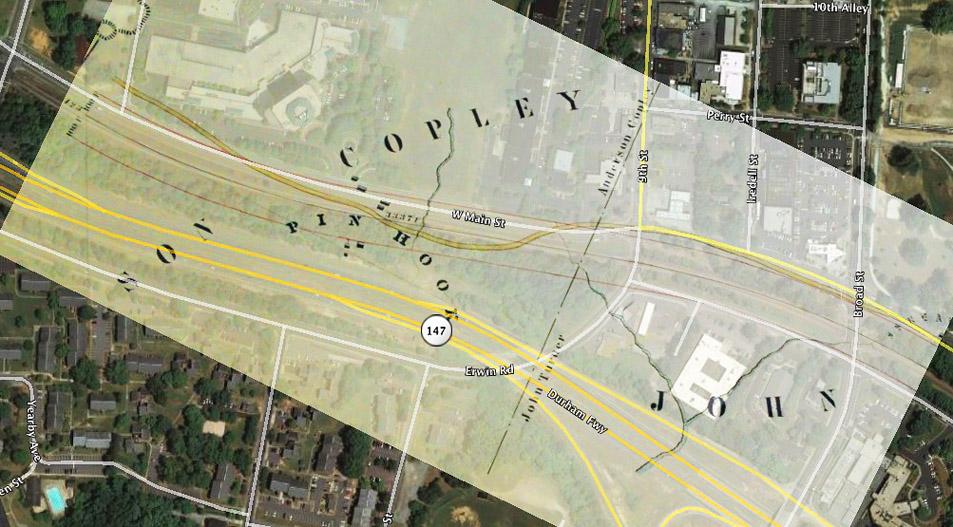
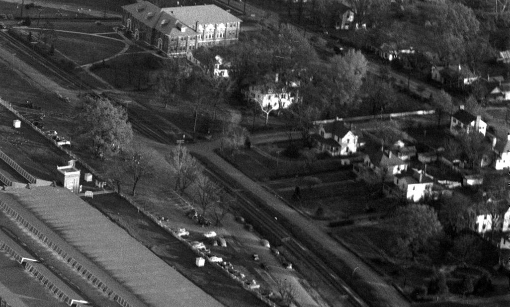
Exactly locating Pinhook is a fun endeavor, and the kind of thing that Durham history geeks like me like to debate. The best representation of the location of Pinhook is given by the North Carolina railroad survey map, drawn in 1850. A beautiful set of large maps, located in the state archives, they document the charted course of the planned railroad, including land owners and settlement on or proximate to the right-of-way. While descriptions state that Pinhook was located "100 yards southwest from the corner of the Erwin Mill" the survey maps likely show it with the most accuracy.
Overlay of the RR survey map on present-day satellite photography, matching the centerline of the right-of-way to the curve of the railroad track.
(Picture of the survey provided by Steve Rankin)
Pinhook's days had probably begun to wane by the 1880s, as the railroad running through the middle of the settlement likely reduced traffic on the roadway considerably, and seemingly split it in two. Mercantile needs, as well as a need for spirits, would increasingly be met near the stations, as the early growth of saloons near Durham Station would attest. Also, increasing settlement from the growth of Durham brought increased attention that made it more difficult to carry on in isolation.
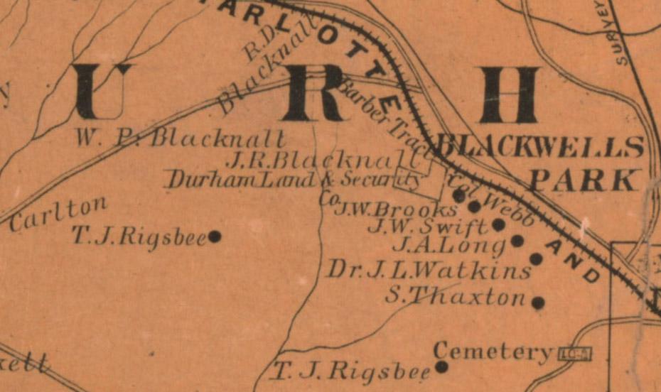
It seems that Pinhook had already begun to be supplanted by houses of some 'significance' by that time, as an 1887 map shows settlement along the south side of the railroad tracks.
Residents along what would be known as Railroad Street, eventually West Pettigrew, 1887
(Courtesy University of North Carolina)
Many of these people were associated with industry in Durham, such as JW Swift, a "tobacco buyer" who worked on Roney St., JA Long a foreman at the Duke Tobacco Factory, Dr. JL Watkins, a "leaf dealer" who worked on Morris St. JW Brooks is listed as a real estate agent in 1889, which makes me wonder if he was somehow involved in the 'gentrification' of Pinhook. Brookstown would be named after him, although I don't know his relationship to that African-American settlement to the southeast.
By 1892, Brooks is listed as a "plug dealer for Alliance Plug Factory" (plug was a type of tobacco) and as a resident of Caswell Hill. I do not know the origin of the name, but given that it is sometimes referred to as "Casewell Hill" (or Heights) and there is a Case Street, I assume that the name was somehow derived from a Mr/Ms Case, who I have not tracked down. However, all of the residents of this area are referred to as living in Caswell Hill by that year.
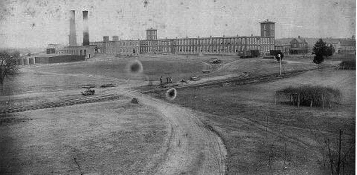
If there were any remnants of Pinhook by that time, the finality came when Ben Duke, George Watts, and William Erwin practiced the 1890s version of urban renewal (although they actually built something) acquiring large tracts of land for the construction of Erwin Cotton Mill and the surrounding village. By the time the original mill was constructed in 1893, and expanded in 1898, there was clearly no further evidence of Pinhook. Interestingly, Julian Carr would repeat this same pattern as he flattened Smoky Hollow to create Edgemont/Morning Glory (and Durham Hosiery Mill No.1 & Golden Belt) in 1901.
Site of Pinhook, looking north across the railroad tracks. The housing noted above was behind and to the right of the photographer.
(Courtesy Old West Durham)
With the construction of the Erwin Mill, Caswell Hill became part of the mill village, housing supervisors, owners and the like. Brooks and Swift seem to have disappeared by the late 1890s, although the 1910 map below still shows Brooks' name. It also shows that these houses were increasingly acquired by Erwin Mills to provide housing for employees. The area associated with Pinhook on the north side of the road/railroad was eventually redeveloped as part of Mill No. 4, built in 1909.
Caswell Hill, 1910. Houses owned by Erwin Mill are white, others are shaded.
(Courtesy Duke RBMC - digitized by Digital Durham)
Occupants of the specific houses on the south side of the tracks are difficult to track down prior to 1925, but a rather scattershot accounting of occupants from the late 1920s, late 1930s, and mid 1950s, living between the Erwin Auditorium and 14th (Rutherford) Street:
1709 West Pettigrew: Parks, PB; Byers, Walton V; Cooke, Robert
1715 West Pettigrew: Blacknall, JC Mrs.; Parks, Paul B; Byers, Walton V..
1801 West Pettigrew: Ward, WP; Blacknall, Josephine; Benson, Dwight M
1805 West Pettigrew: Poe, CT; Same; Same
1807 West Pettigrew: Cable, LB; Bunting Carl L; Woodruff, Percy and Hitt, Marlin
1811 West Pettigrew: Cooke, NA Mrs.; Gery, Delma; Jones, Thos.
1815 West Pettigrew: Hawes, AD; Heldman, Jas; Smart, Oscar
1819 West Pettigrew: Agner, AL; Agner, Adam; Nash, Chas E
1823 West Pettigrew: Byrd, WT; Same; Wiley William T
1825 West Pettigrew:Reese, AM; Faris, Aubry; Sam
A partial view of the houses along West Pettigrew Street, terminating in Erwin Auditorium (to be profiled next week), 1950s
(Courtesy Herald Sun)
It isn't clear when these houses were torn down, but they were certainly down by 1984, when demolition along West Pettigrew Street occurred in advance of the construction of the Erwin->15-501 leg of the Durham Freeway.
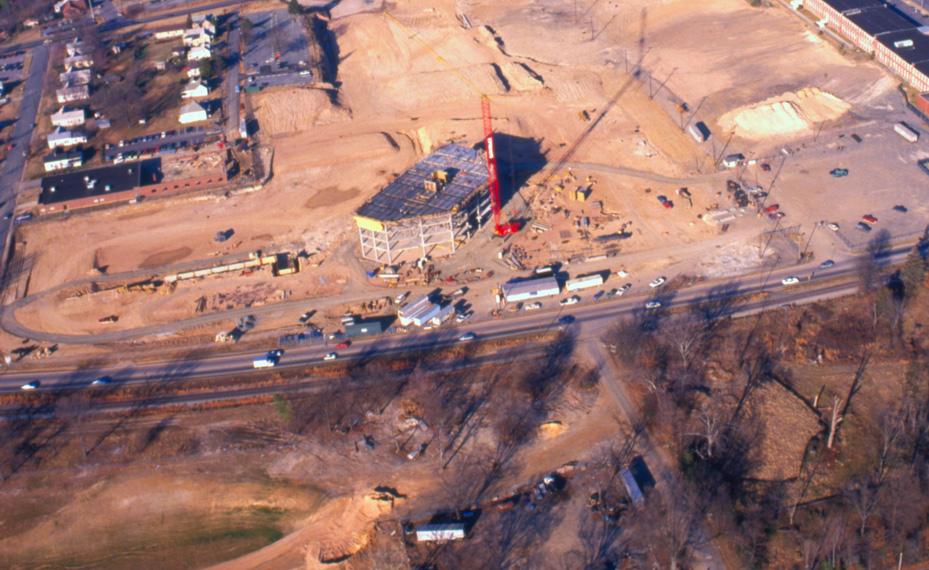
The below 1989 shot of the construction of Erwin Square shows the cleared land on the south side of the railroad tracks.
Looking north at the construction of Erwin Square, 02.01.89
(Courtesy Herald Sun)
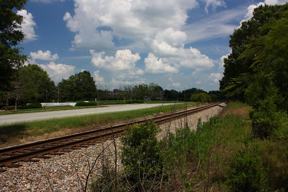
Today, the location of Pinhook would sit around the roundabout entrance to Erwin Square, and in the no-man's-land between the railroad and the Durham Freeway - a desolate evolution for a place that once hosted such boisterous behavior.
Site of Pinhook, 06.13.09
I'm happy to report that the name has been rejuvenated in the form of a great little bar that opened last fall - not at Pinhook proper (as if it ever was) but at 119 West Main Street.
Find this spot on a Google Map.
36.006728,-78.925253

Comments
Submitted by John Schelp (not verified) on Fri, 6/19/2009 - 9:55pm
Awesome, Gary!
Those interested in reading the 1906 account of Pinhook (mentioned above) can click here... http://www.owdna.org/History/history20.htm
Submitted by Anonymous (not verified) on Sat, 6/20/2009 - 3:20am
My Mother was not aware of any property specifically in that area sout of now Erwin owned by her Great Grandfather-TJ Rigsbee.
We knew about land owned at the site of Wallace Wade and farther away as well as downtown proper.
Great research, Gary!
Thanks,
Seth Roberts
seth@realtor.com
Submitted by David Southern (not verified) on Thu, 11/10/2011 - 4:18pm
From Kemp P. Battle's History of the University of North Carolina (1907, volume 1, page 583):
"A circus was once held at what was called Pinhook, now West Durham. Quite a company ran off to witness it. Some came very near a fight with the circus men, which would have been a serious matter, as there were practically no police officers to interfere. The conflict was averted by Thomas E. Skinner, late a Reverend Doctor, who in those days was not averse to breaking University law for such transcendent bliss as was found under the canvass, but who abstained from strong drink and kept his head. He induced the manager to start suddenly such an exhibition of acrobatic agility and such a blaze of brilliant scenery, as to surprise his friends into forgetfulness of their wrath."
The grape arbor in the foreground of that wonderful photo that John Schelp turned up is almost certainly a scuppernong. The superimposition of the 1850 North Carolina Rail Road survey map at scale atop the present-day aerial photo is absolutely congruent---an impressive feat. Some of the feeder creeks shown on the RR map later show up running through large underground pipes on the Sanborn insurance maps, perhaps one of the two you show, running northeast, eventually through Walltown, to connect with Ellerbee Creek.
Submitted by David Southern (not verified) on Thu, 11/10/2011 - 4:22pm
And more from President Battle (volume 1, pages 583 and 584):
A parody on the opening verses of Byron's Bride of Abydos, written by the late Solicitor General S. F. Phillips, in 1853, contains many local allusions and is on the whole founded on fact.
Know ye the land where the black-board and Homer
Are direst of curses to Sophs and to Fresh?
Where the fear of dismissal, the hope of diploma,
Never chequer the dreams of an idle malish?
Know ye of rock walls and ditches the land,
Where the granite is brickwork, the terraces sand?
Where the speeches of Seniors, quotation oppressed,
Page 584
In the opinion of Subs will rank with the best?
Where demand and supply, your all conquering law
Robs barrels and hen-roosts from Pinhook to Haw?
Where the 'possums and 'simmons are fairest of fruit,
And the lunatic serenade never is mute?
Where groves are as green as the students they shade,
And naught can be worse than the warm lemonade?
'Tis the land where the Juniors, sworn foeman to books,
Beats College all hollow in playing for knucks,
From supper till sundown still kneels at his taw,
Where students and shaving are "done" by Dave Moore?
'Tis the site of the Chapel, the slope of the Hill,
Can it smile on such potions as students will swill?
Oh! passing the absurda of blackboard and chalk,
Are the liquors they drink and the nonsense they talk!
Some explanation of the poem may be useful. The optional student, or malish (militia), usually resided in the village and escaped strict surveillance. He could obtain no diploma or certificate of any kind. The buildings were colored and one, Smith Hall, was stuccoed to resemble granite. There were terraces around the Old East and Old West buildings, on which the grass was not then growing. At the spring Senior Speaking the Marshal and his "Subs" kept order. They sat conspicuously in front of the speakers and seemed to, as a part of their office, admire their utterances. Pinhook was a crossroads about twelve miles east of Chapel Hill and Haw River is about the same distance to the west. In older days when boarding "at Commons" was compulsory, the Steward being the lowest bidder, there was a practice among some of supplementing the meagreness of the table by purloining "hen products," but the crime had become rare. The only nocturnal raids were for fruit, especially scuppernong grapes. It is a source of sincere regret that the opossum is fast becoming extinct in our woods. Hunting them at night was once a pleasant and profitable pastime.
Add new comment
Log in or register to post comments.